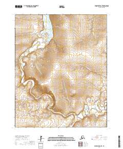
2017 Map of Bendeleben D-2 NE
USGS Topo · Published 2017About this map
The Kugruk River winds through this section of the Northwest Arctic Borough, serving as the primary drainage for the area's interior basins. The landscape is defined by its complex hydrology, where smaller tributaries like California Cr and Portage Cr feed into the larger river systems. In the southern portion of the sheet, the Burnt River flows through the survey blocks of t6n r19w and t6n r18w, illustrating the remote wilderness of the Seward Peninsula region. This 2017 survey provides a precise look at the natural watercourses and topography in an area largely devoid of permanent human infrastructure or roads, emphasizing the region's untouched character.
Find a feature on this map
8 named features on this map. Tap any name to fly to it.
Don’t see what you’re looking for? This feature index may not catch every label — zoom into the map to look around manually.
Map Details
Editions of this 2017 Bendeleben D-2 NE Map
This is the sole edition of this map. No revisions or reprints were ever made.
Other maps of this area

1950 · Kotzebue A-1
USGS Topo · 1:63,360

1950 · Bendeleben D-2
USGS Topo · 1:63,360

1950 · Bendeleben
USGS Topo · 1:250,000

1950 · Bendeleben D-1
USGS Topo · 1:63,360

1950 · Kotzebue A-2
USGS Topo · 1:63,360

1951 · Bendeleben
USGS Topo · 1:250,000

1951 · Kotzebue
USGS Topo · 1:250,000

1958 · Kotzebue
USGS Topo · 1:250,000

1964 · Bendeleben
USGS Topo · 1:250,000

1964 · Kotzebue
USGS Topo · 1:250,000