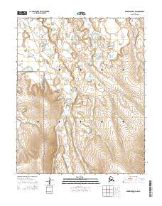
2014 Map of Bendeleben D-6 NW
USGS Topo · Published 2014About this map
Bering Land Bridge National Preserve dominates this Arctic landscape on the Seward Peninsula, protecting a vast watershed where the Serpentine River and its many tributaries converge. The map documents the intricate hydrography of the region, specifically the N Fork Serpentine River and several significant creeks including Rock Cr, Schlitz Cr, and Bryan Cr. The presence of Hot Springs Cr suggests the geothermal activity that has historically drawn travelers and researchers to this remote corner of Alaska. This 2014 survey serves as a modern record of an ancient migration corridor, illustrating how the natural drainage systems define the boundaries and accessibility of the protected preserve land.
Find a feature on this map
11 named features on this map. Tap any name to fly to it.
Don’t see what you’re looking for? This feature index may not catch every label — zoom into the map to look around manually.
Map Details
Editions of this 2014 Bendeleben D-6 NW Map
This is the sole edition of this map. No revisions or reprints were ever made.
Other maps of this area

1950 · Bendeleben D-6
USGS Topo · 1:63,360

1950 · Teller
USGS Topo · 1:250,000

1950 · Bendeleben
USGS Topo · 1:250,000

1950 · Shishmaref
USGS Topo · 1:250,000

1950 · Shishmaref A-1
USGS Topo · 1:63,360

1950 · Kotzebue A-6
USGS Topo · 1:63,360

1950 · Teller D-1
USGS Topo · 1:63,360

1951 · Shishmaref
USGS Topo · 1:250,000

1951 · Bendeleben
USGS Topo · 1:250,000

1951 · Kotzebue
USGS Topo · 1:250,000