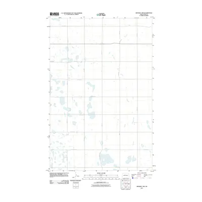
2011 Map of Benedict NW
USGS Topo · Published 2011About this map
Oak Creek meanders through this portion of Ward County, defining the drainage patterns in a landscape punctuated by numerous small prairie potholes and wetlands. The area is structured by a rigorous grid of section-line roads, such as 233rd Ave SE and 42nd St SE, which facilitate the region's agricultural movement. This 2011 survey by the U.S. Geological Survey illustrates a sparsely populated rural territory where the natural hydrography of the Northern Plains persists alongside organized land use. Key corridors like 85th St SE and 72nd St SE intersect the terrain, providing a look at the modern rural infrastructure. The map reflects a quiet pocket of North Dakota where small-scale water features dominate the topography between the established gravel and paved routes.
Find a feature on this map
18 named features on this map. Tap any name to fly to it.
Don’t see what you’re looking for? This feature index may not catch every label — zoom into the map to look around manually.
Map Details
Editions of this 2011 Benedict NW Map
This is the sole edition of this map. No revisions or reprints were ever made.
Other maps of this area

1928 · Minot
USGS Topo · 1:62,500

1929 · Sawyer
USGS Topo · 1:62,500

1929 · Benedict
USGS Topo · 1:62,500

1948 · Sawyer
USGS Topo · 1:24,000

1949 · Sawyer
USGS Topo · 1:24,000

1949 · Sawyer
USGS Topo · 1:62,500
1950 · Sawyer SW
USGS Topo · 1:24,000

1954 · Minot
USGS Topo · 1:250,000

1954 · McClusky
USGS Topo · 1:250,000

1958 · McClusky
USGS Topo · 1:250,000