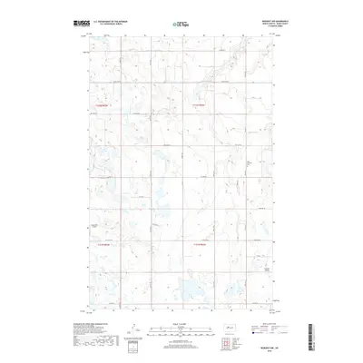
2018 Map of Benedict NW
USGS Topo · Published 2018About this map
Oak Cr meanders through this agricultural landscape in Ward County, defining a topography of prairie potholes and subtle drainage basins. The area is characterized by a high density of small, seasonal wetlands and ponds, reflecting the glacial history of the North Dakota plains. Evidence of local community life appears at the Hope Lutheran Cem along 97th St SE, a landmark for genealogical research in this rural township. Transport and connectivity are provided by a grid of section-line roads and larger routes like Co Hwy 22 and Co Hwy 24, which link isolated farmsteads and the Poleschook Airport. In the southeastern corner, the land dips toward Bonnes Coulee, showing the transition from upland fields to deeper drainage features.
Find a feature on this map
25 named features on this map. Tap any name to fly to it.
Don’t see what you’re looking for? This feature index may not catch every label — zoom into the map to look around manually.
Map Details
Editions of this 2018 Benedict NW Map
This is the sole edition of this map. No revisions or reprints were ever made.
Other maps of this area

1928 · Minot
USGS Topo · 1:62,500

1929 · Sawyer
USGS Topo · 1:62,500

1929 · Benedict
USGS Topo · 1:62,500

1948 · Sawyer
USGS Topo · 1:24,000

1949 · Sawyer
USGS Topo · 1:24,000

1949 · Sawyer
USGS Topo · 1:62,500
1950 · Sawyer SW
USGS Topo · 1:24,000

1954 · Minot
USGS Topo · 1:250,000

1954 · McClusky
USGS Topo · 1:250,000

1958 · McClusky
USGS Topo · 1:250,000