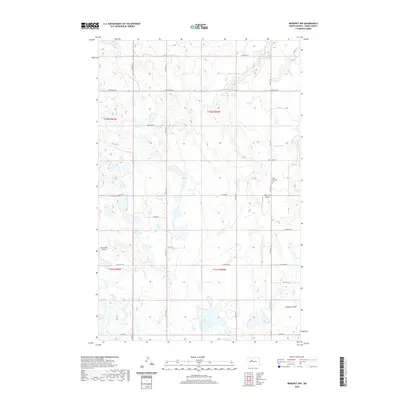
2020 Map of Benedict NW
USGS Topo · Published 2020About this map
Oak Creek meanders through this agricultural landscape in southeastern Ward County, carving a shallow valley that defines the local topography. This 2020 map documents a region where transportation and rural services are anchored by small-scale infrastructure like Oak Creek Airport and the Poleschook Airport, reflecting the logistical needs of modern prairie farming. Near the intersection of County Highway 21 and 275th Avenue SE, the Hope Lutheran Cemetery stands as a focal point for local genealogy and heritage. The terrain is further characterized by Bonnes Coulee and a network of section-line roads, such as 247th Avenue SE and 42nd Street SE, which maintain the rigid grid system established over a century ago.
Find a feature on this map
26 named features on this map. Tap any name to fly to it.
Don’t see what you’re looking for? This feature index may not catch every label — zoom into the map to look around manually.
Map Details
Editions of this 2020 Benedict NW Map
This is the sole edition of this map. No revisions or reprints were ever made.
Other maps of this area

1928 · Minot
USGS Topo · 1:62,500

1929 · Sawyer
USGS Topo · 1:62,500

1929 · Benedict
USGS Topo · 1:62,500

1948 · Sawyer
USGS Topo · 1:24,000

1949 · Sawyer
USGS Topo · 1:24,000

1949 · Sawyer
USGS Topo · 1:62,500
1950 · Sawyer SW
USGS Topo · 1:24,000

1954 · Minot
USGS Topo · 1:250,000

1954 · McClusky
USGS Topo · 1:250,000

1958 · McClusky
USGS Topo · 1:250,000