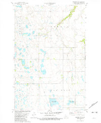
1981 Map of Benedict NW
USGS Topo · Published 1982About this map
The low-lying prairie of Ward County is defined by its extensive wetlands and conservation areas as they appeared in the early 1980s. Large tracts of the National Waterfowl Production Area dominate the southern landscape, interspersed with small lakes and ponds across Iota Flat and Gassman. This topography reflects the glacial history of the region, where internal drainage and kettle ponds are common. Small community nodes are scattered throughout the agricultural grid, including the Townhall settlement and the isolated Kabanuk. Local religious and social life is centered at Hope Ch and the adjacent Hope Cem in the northeastern corner. Infrastructure for the energy and agriculture sectors is evident through a major Pipeline crossing the flats and a dedicated Landing Field, likely serving local crop dusting or general aviation needs in this rural corridor near Oak Creek.
Find a feature on this map
14 named features on this map. Tap any name to fly to it.
Don’t see what you’re looking for? This feature index may not catch every label — zoom into the map to look around manually.
Map Details
Editions of this 1981 Benedict NW Map
This is the sole edition of this map. No revisions or reprints were ever made.
Other maps of this area

1928 · Minot
USGS Topo · 1:62,500

1929 · Sawyer
USGS Topo · 1:62,500

1929 · Benedict
USGS Topo · 1:62,500

1948 · Sawyer
USGS Topo · 1:24,000

1949 · Sawyer
USGS Topo · 1:24,000

1949 · Sawyer
USGS Topo · 1:62,500
1950 · Sawyer SW
USGS Topo · 1:24,000

1954 · Minot
USGS Topo · 1:250,000

1954 · McClusky
USGS Topo · 1:250,000

1958 · McClusky
USGS Topo · 1:250,000