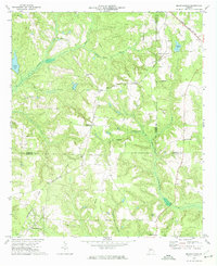
1972 Map of Benevolence
USGS Topo · Published 1974About this map
Benevolence and Brooksville anchor this rural landscape in the early 1970s, situated where the borders of Stewart, Webster, and Randolph counties converge. The terrain is defined by the winding course of Ichawaynochaway Creek and its many tributaries, such as Lime Spring Branch and Soapstone Branch. This era shows a community rooted in its local institutions, with numerous country churches scattered across the hills, including Mt Olive Ch, Mt Pleasant Ch, and Mt Airy Ch. The Seaboard Coast Line railroad cuts diagonally across the northern and western sections, connecting small sidings and hamlets like Lester and Barges to the wider region. Small agricultural water features like Singer Pond and Goodwins Pond are interspersed among the drainages of Pataula Creek, illustrating the long-standing land use patterns of Southwest Georgia.
Find a feature on this map
28 named features on this map. Tap any name to fly to it.
Don’t see what you’re looking for? This feature index may not catch every label — zoom into the map to look around manually.
Map Details
Editions of this 1972 Benevolence Map
This is the sole edition of this map. No revisions or reprints were ever made.
Other maps of this area

1950 · Lumpkin
USGS Topo · 1:24,000

1950 · Lumpkin
USGS Topo · 1:62,500

1953 · Dothan
USGS Topo · 1:250,000

1954 · Dothan
USGS Topo · 1:250,000

1955 · Dothan
USGS Topo · 1:250,000

1955 · Lumpkin
USGS Topo · 1:24,000

1955 · Lumpkin
USGS Topo · 1:62,500

1955 · Phenix City
USGS Topo · 1:250,000

1957 · Phenix City
USGS Topo · 1:250,000

1958 · Phenix City
USGS Topo · 1:250,000