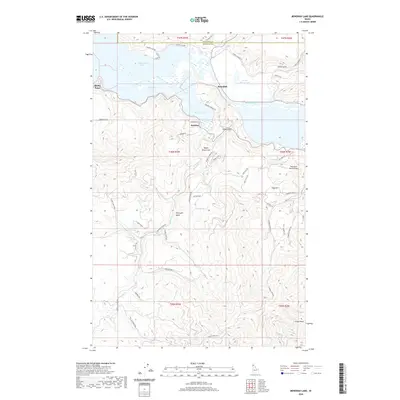
2020 Map of Benewah Lake
USGS Topo · Published 2020About this map
Benewah Lake and Chatcolet Lake dominate this northern Idaho landscape, joined by the winding course of the Saint Joe River. The map illustrates a complex riparian environment where the river interacts with several water bodies, including Goose Heaven Lake and the distinctively named Hn'a'yqhn Bend. Small settlements such as Ramsdell and Parkline are positioned along the slopes and shorelines, connected by a network of local roads like Benewah Resort Rd and Round Lake Rd. The terrain is defined by significant elevations such as Negro Brown Hill, Shay Hill, and Poschs Hill, which rise above the river valley. Notable local infrastructure includes the Sky Island Ranch Airport and various creek systems like Benewah Cr and Cherry Cr, which drain the surrounding highlands toward the central lake system.
Find a feature on this map
55 named features on this map. Tap any name to fly to it.
Don’t see what you’re looking for? This feature index may not catch every label — zoom into the map to look around manually.
Map Details
Editions of this 2020 Benewah Lake Map
This is the sole edition of this map. No revisions or reprints were ever made.
Other maps of this area

1955 · Spokane
USGS Topo · 1:250,000

1957 · St. Maries
USGS Topo · 1:62,500

1957 · Emida
USGS Topo · 1:62,500

1957 · Plummer
USGS Topo · 1:62,500

1957 · Tensed
USGS Topo · 1:62,500

1958 · Spokane
USGS Topo · 1:250,000

1975 · Plummer SE
USGS Topo · 1:24,000

1975 · Plummer NE
USGS Topo · 1:24,000

1981 · St Maries
USGS Topo · 1:100,000
1981 · Medimont
USGS Topo · 1:24,000