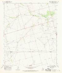
1968 Map of Benge Corner
USGS Topo · Published 1970About this map
Johnson Draw carves a path through the Permian Basin landscape, defining the topography of this high plains region in the late 1960s. The area is dominated by the industrial infrastructure of the Pegasus Oil Field, where a dense network of pipelines and scattered oil wells reflects the intensive petroleum extraction of the era. Settlement is sparse, anchored by the crossroads at Benge Corner, located near the Midland Co and Upton Co line. An indefinite boundary separates the two counties, crossing open ranch land where fine red dashed lines denote the presence of property fences. The presence of numerous gravel pits and specialized drilling infrastructure highlights a landscape repurposed for resource extraction, offering a clear view of the mid-century oil boom's physical footprint on the West Texas terrain.
Find a feature on this map
9 named features on this map. Tap any name to fly to it.
Don’t see what you’re looking for? This feature index may not catch every label — zoom into the map to look around manually.
Map Details
Editions of this 1968 Benge Corner Map
This is the sole edition of this map. No revisions or reprints were ever made.
Other maps of this area

1954 · Pecos
USGS Topo · 1:250,000

1954 · San Angelo
USGS Topo · 1:250,000

1957 · Pecos
USGS Topo · 1:250,000

1958 · San Angelo
USGS Topo · 1:250,000

1964 · Bryant Ranch
USGS Topo · 1:24,000

1964 · Parks
USGS Topo · 1:24,000

1965 · San Angelo
USGS Topo · 1:250,000

1965 · Salt Lake
USGS Topo · 1:24,000

1968 · Benge Corner SE
USGS Topo · 1:24,000

1968 · Benge Corner NW
USGS Topo · 1:24,000