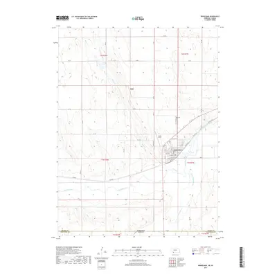
2017 Map of Benkelman
USGS Topo · Published 2017About this map
The confluence of the Republican River and the S Fork Republican River defines the landscape surrounding Benkelman, the county seat of Dundy County. This 2017 survey shows the town’s grid tightly integrated with the rail corridor, where Railroad St and E Railroad St parallel the tracks passing through the heart of the community. The surrounding terrain is a network of drainage systems and intermittent water features, including Spring Cr, Big Timber Cr, and the Twin Lakes. Small aviation facilities such as Hoppy's Airport and Jones Airport suggest the expansive, rural nature of the Nebraska-Kansas borderlands. Just north of the main settlement, the Benkelman Cem stands as a primary genealogical landmark for researchers of this High Plains region.
Find a feature on this map
33 named features on this map. Tap any name to fly to it.
Don’t see what you’re looking for? This feature index may not catch every label — zoom into the map to look around manually.
Map Details
Editions of this 2017 Benkelman Map
This is the sole edition of this map. No revisions or reprints were ever made.
Other maps of this area

1950 · Mc Donald
USGS Topo · 1:62,500

1951 · Bird City North
USGS Topo · 1:62,500

1951 · Mc Donald
USGS Topo · 1:62,500

1954 · McCook
USGS Topo · 1:250,000

1954 · Goodland
USGS Topo · 1:250,000

1956 · Goodland
USGS Topo · 1:250,000

1957 · McCook
USGS Topo · 1:250,000

1957 · Goodland
USGS Topo · 1:250,000

1958 · McCook
USGS Topo · 1:250,000
1961 · Parks
USGS Topo · 1:24,000
Featured Places
- Benkelman, NE
- Rainbow Fountain Park, Benkelman
- Baney Trailer Park, Benkelman
- Merklin Trailer Court, Benkelman
- Cheyenne County, KS