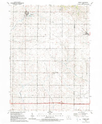
1991 Map of Bennett
USGS Topo · Published 1992About this map
Bennett stands as the primary community in this late-twentieth-century depiction of the eastern Iowa landscape, where the town's grid is established north of Bennett Creek. The survey reveals a region defined by agricultural townships including Inland and Farmington in Cedar County, extending across the border into Liberty and Cleona in Scott County. Small settlements such as Sunbury and New Liberty are documented alongside specialized local infrastructure like the Sewage Disposal Ponds and a network of buried pipelines. Drainage patterns are clearly marked by the winding paths of Mud Creek and Little Elkhorn Creek, while Bennett Park provides a dedicated public space north of the main settlement. The map serves as a detailed record of rural land divisions and township boundaries at a time of established modern agricultural practice.
Find a feature on this map
15 named features on this map. Tap any name to fly to it.
Don’t see what you’re looking for? This feature index may not catch every label — zoom into the map to look around manually.
Map Details
Editions of this 1991 Bennett Map
This is the sole edition of this map. No revisions or reprints were ever made.
Other maps of this area

1889 · Tipton
USGS Topo · 1:62,500

1890 · Durant
USGS Topo · 1:62,500

1890 · Tipton
USGS Topo · 1:62,500

1891 · Wilton Junction
USGS Topo · 1:62,500

1892 · Wheatland
USGS Topo · 1:62,500

1894 · Wheatland
USGS Topo · 1:62,500

1894 · Durant
USGS Topo · 1:62,500

1901 · Rock Island
USGS Topo · 1:125,000

1901 · Stanwood
USGS Topo · 1:125,000

1910 · Rock Island
USGS Topo · 1:125,000