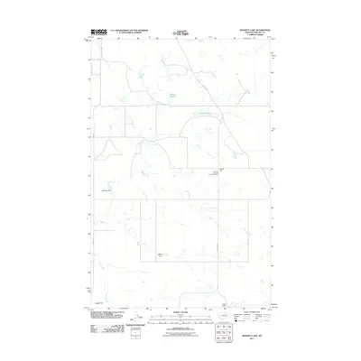
2011 Map of Bennett Lake
USGS Topo · Published 2011About this map
Scandia Lutheran Church Cemetery serves as a central landmark in this sparse region of Phillips County, where the high plains landscape is defined by its intermittent water features and drainage systems. This 2011 survey illustrates a remote prairie environment where land management is visible through numerous man-made structures like Robinson Dam, Lefdehl Dam, and Colen Dam. These modifications to the drainage basin, including the catchment at Bennett Lake, suggest a continued reliance on water conservation for ranching and agriculture in an area otherwise marked by the expansive Alkali Flat. Regional transport is facilitated by a grid of named routes such as Sun Prairie Rd and Content Rd, which connect the isolated cemetery and various water bodies like Solberg Slough across the open terrain.
Find a feature on this map
13 named features on this map. Tap any name to fly to it.
Don’t see what you’re looking for? This feature index may not catch every label — zoom into the map to look around manually.
Map Details
Editions of this 2011 Bennett Lake Map
This is the sole edition of this map. No revisions or reprints were ever made.
Other maps of this area

1905 · Bowdoin
USGS Topo · 1:62,500

1954 · Glasgow
USGS Topo · 1:250,000

1957 · Glasgow
USGS Topo · 1:250,000

1958 · Glasgow
USGS Topo · 1:250,000

1968 · Malta West
USGS Topo · 1:24,000

1968 · Malta East
USGS Topo · 1:24,000

1984 · Clanton Coulee
USGS Topo · 1:24,000
1984 · Horse Pasture Coulee
USGS Topo · 1:24,000
1984 · Mitchell Corner
USGS Topo · 1:24,000
1984 · Bennett Lake NW
USGS Topo · 1:24,000