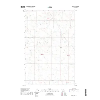
2020 Map of Bennett Lake
USGS Topo · Published 2020About this map
Scandia Lutheran Church and its accompanying Scandia Lutheran Church Cem stand as significant landmarks within this section of Phillips County, indicating the area's religious and community heritage. The landscape is defined by the ephemeral waters of Bennett Lake and the drainage of D H S Cr, alongside the topographic incision of Brown Coulee. The rural infrastructure is mapped through a series of long-established thoroughfares such as Regina Rd and Sun Prairie Rd, which delineate the vast section lines of the Public Land Survey System. This documentation of township and range boundaries, from t29n r30e to t27n r31e, provides a clear view of the organized agricultural and ranching grid that has shaped the high plains of north-central Montana into the twenty-first century.
Find a feature on this map
16 named features on this map. Tap any name to fly to it.
Don’t see what you’re looking for? This feature index may not catch every label — zoom into the map to look around manually.
Map Details
Editions of this 2020 Bennett Lake Map
This is the sole edition of this map. No revisions or reprints were ever made.
Other maps of this area

1905 · Bowdoin
USGS Topo · 1:62,500

1954 · Glasgow
USGS Topo · 1:250,000

1957 · Glasgow
USGS Topo · 1:250,000

1958 · Glasgow
USGS Topo · 1:250,000

1968 · Malta West
USGS Topo · 1:24,000

1968 · Malta East
USGS Topo · 1:24,000

1984 · Clanton Coulee
USGS Topo · 1:24,000
1984 · Horse Pasture Coulee
USGS Topo · 1:24,000
1984 · Mitchell Corner
USGS Topo · 1:24,000
1984 · Bennett Lake NW
USGS Topo · 1:24,000