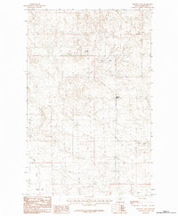
1984 Map of Bennett Lake
USGS Topo · Published 1984About this map
Bennett Lake and the surrounding Phillips County plains are captured here in a 1984 survey that emphasizes the delicate hydrology of the northern Missouri River breaks region. This landscape is defined by its seasonal water features and intermittent drainages, including the elongated Solberg Slough and the winding course of DHS Creek. The presence of the Alkali Flat and Alkali Creek indicates a terrain shaped by mineral deposits and high evaporation rates, common in this part of Montana. As a provisional edition based on 1978 field checks, the map provides a look at the township and range grid across these northern reaches, specifically documenting the boundaries between Townships 27 and 28 North.
Find a feature on this map
7 named features on this map. Tap any name to fly to it.
Don’t see what you’re looking for? This feature index may not catch every label — zoom into the map to look around manually.
Map Details
Editions of this 1984 Bennett Lake Map
This is the sole edition of this map. No revisions or reprints were ever made.
Other maps of this area

1905 · Bowdoin
USGS Topo · 1:62,500

1954 · Glasgow
USGS Topo · 1:250,000

1957 · Glasgow
USGS Topo · 1:250,000

1958 · Glasgow
USGS Topo · 1:250,000

1968 · Malta West
USGS Topo · 1:24,000

1968 · Malta East
USGS Topo · 1:24,000

1984 · Clanton Coulee
USGS Topo · 1:24,000
1984 · Horse Pasture Coulee
USGS Topo · 1:24,000
1984 · Mitchell Corner
USGS Topo · 1:24,000
1984 · Bennett Lake NW
USGS Topo · 1:24,000