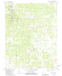
1982 Map of Bennett Springs
USGS Topo · Published 1983About this map
Bennett Springs and the surrounding Ozark terrain are defined by the convergence of the Niangua River and the significant spring system that anchors Bennett Spring State Park. This 1980s-era documentation captures the landscape just before modern expansions, highlighting a network of rural life centered on the Laclede and Dallas county line. The map reveals a high density of community landmarks, including the Sportsmen Outdoor Chapel, Flatwoods Ch, and Oak Grove Ch.
Find a feature on this map
36 named features on this map. Tap any name to fly to it.
Don’t see what you’re looking for? This feature index may not catch every label — zoom into the map to look around manually.
Map Details
Editions of this 1982 Bennett Springs Map
This is the sole edition of this map. No revisions or reprints were ever made.
Other maps of this area

1933 · Stoutland
USGS Topo · 1:62,500

1934 · Macks Creek
USGS Topo · 1:48,000

1938 · Stoutland
USGS Topo · 1:62,500

1939 · Macks Creek
USGS Topo · 1:62,500

1939 · Long Lane
USGS Topo · 1:62,500

1941 · Lebanon
USGS Topo · 1:62,500

1942 · Long Lane
USGS Topo · 1:62,500

1943 · Lebanon
USGS Topo · 1:62,500

1954 · Springfield
USGS Topo · 1:250,000

1958 · Springfield
USGS Topo · 1:250,000