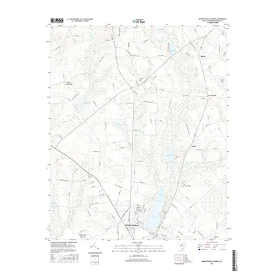
2017 Map of Bennettsville North
USGS Topo · Published 2017About this map
Lake Wallace dominates the southern landscape, serving as a focal point for the northern expansion of Bennettsville in this 2017 survey. The region is defined by a complex network of coastal plain drainage, where Crooked Creek and Lilly Quick Creek feed into a series of historically significant impoundments including Bullards Millpond, Davids Millpond, and Burnt Factory Pond. These water bodies and their surrounding wetlands reflect a long-standing reliance on local hydraulic resources for agricultural and industrial processing in Marlboro County.
Find a feature on this map
124 named features on this map. Tap any name to fly to it.
Don’t see what you’re looking for? This feature index may not catch every label — zoom into the map to look around manually.
Map Details
Editions of this 2017 Bennettsville North Map
This is the sole edition of this map. No revisions or reprints were ever made.
Other maps of this area

1942 · Rockingham
USGS Topo · 1:125,000

1949 · Gibson
USGS Topo · 1:24,000

1949 · Ghio
USGS Topo · 1:24,000

1949 · Hamlet
USGS Topo · 1:62,500

1953 · Florence
USGS Topo · 1:250,000

1954 · Florence
USGS Topo · 1:250,000
1971 · Diggs
USGS Topo · 1:24,000
1971 · Wallace
USGS Topo · 1:24,000

1971 · Society Hill
USGS Topo · 1:24,000

1972 · Clio
USGS Topo · 1:24,000