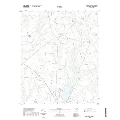
2020 Map of Bennettsville North
USGS Topo · Published 2020About this map
Lake Wallace serves as a central hydrological landmark in this northern Marlboro County landscape, situated just above the city of Bennettsville. The area's agricultural and industrial heritage is written into the terrain through numerous impoundments and ponds, including Bullards Millpond, Burnt Factory Pond, and Goodwins Millpond, many of which follow the course of Crooked Cr. This 2020 survey illustrates the transition from the concentrated residential streets of the county seat to the outlying rural communities of Boykin, Lester, and Newtonville. Genealogists will find a significant distribution of local burial sites, from Hubbard Cem near the Antioch Church to the Marlboro County Cem and Beauty Spot Cem. The southwestern portion is anchored by transportation infrastructure, specifically the Marlboro County Jetport - H E Avent Field.
Find a feature on this map
125 named features on this map. Tap any name to fly to it.
Don’t see what you’re looking for? This feature index may not catch every label — zoom into the map to look around manually.
Map Details
Editions of this 2020 Bennettsville North Map
This is the sole edition of this map. No revisions or reprints were ever made.
Other maps of this area

1942 · Rockingham
USGS Topo · 1:125,000

1949 · Gibson
USGS Topo · 1:24,000

1949 · Ghio
USGS Topo · 1:24,000

1949 · Hamlet
USGS Topo · 1:62,500

1953 · Florence
USGS Topo · 1:250,000

1954 · Florence
USGS Topo · 1:250,000
1971 · Diggs
USGS Topo · 1:24,000
1971 · Wallace
USGS Topo · 1:24,000

1971 · Society Hill
USGS Topo · 1:24,000

1972 · Clio
USGS Topo · 1:24,000