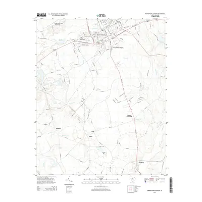
2014 Map of Bennettsville South
USGS Topo · Published 2014About this map
Bennettsville serves as the focal point of this 2014 survey, which covers the residential expansion and hydrological network of central Marlboro County. The town is surrounded by established neighborhoods like Grace Heights, Dundee Acres, and Sunnybrook Heights, while the southern reaches of the map transition into more rural crossroads such as Monroe Crossroads and Blenheim. For those tracing local heritage, the map identifies several significant burial grounds, including Evergreen Cem and the distinctive Beauty Spot Cem in the northeast. Water management and local industry are evidenced by the presence of McCalls Millpond and Covington Millpond, alongside larger bodies like Henegan Lake. The landscape is intricately carved by tributaries including Crooked Cr and Muddy Creek, which drain toward the Great Pee Dee River just beyond the western margins.
Find a feature on this map
51 named features on this map. Tap any name to fly to it.
Don’t see what you’re looking for? This feature index may not catch every label — zoom into the map to look around manually.
Map Details
Editions of this 2014 Bennettsville South Map
This is the sole edition of this map. No revisions or reprints were ever made.
Other maps of this area

1942 · Rockingham
USGS Topo · 1:125,000

1943 · Gum Swamp
USGS Topo · 1:62,500

1953 · Florence
USGS Topo · 1:250,000

1954 · Florence
USGS Topo · 1:250,000

1963 · Mont Clare
USGS Topo · 1:24,000
1971 · Wallace
USGS Topo · 1:24,000

1971 · Society Hill
USGS Topo · 1:24,000

1972 · Drake
USGS Topo · 1:24,000

1972 · Clio
USGS Topo · 1:24,000
1972 · Bennettsville North
USGS Topo · 1:24,000