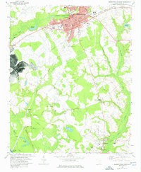
1972 Map of Bennettsville South
USGS Topo · Published 1976About this map
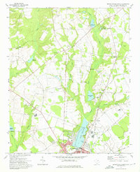
Bennettsville serves as the hub of this mid-1970s landscape, with its dense grid of streets featuring City Hall, the Museum, and a cluster of local churches such as St Pauls Ch and Thomas Memorial Ch. The surrounding Marlboro County countryside is defined by an intricate network of waterways including Crooked Creek and Cottingham Creek, which supported early industry at sites like McCalls Millpond and Covington Millpond.
Find a feature on this map
53 named features on this map. Tap any name to fly to it.
Don’t see what you’re looking for? This feature index may not catch every label — zoom into the map to look around manually.
Map Details
Editions of this 1972 Bennettsville South Map
This is the sole edition of this map. No revisions or reprints were ever made.
Other maps of this area

1942 · Rockingham
USGS Topo · 1:125,000

1943 · Gum Swamp
USGS Topo · 1:62,500

1953 · Florence
USGS Topo · 1:250,000

1954 · Florence
USGS Topo · 1:250,000
1963 · Mont Clare
USGS Topo · 1:24,000
1971 · Wallace
USGS Topo · 1:24,000
1971 · Society Hill
USGS Topo · 1:24,000
1972 · Drake
USGS Topo · 1:24,000
1972 · Clio
USGS Topo · 1:24,000
1972 · Bennettsville North
USGS Topo · 1:24,000