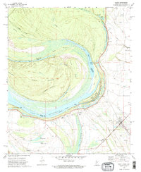
1972 Map of Benoit
USGS Topo · Published 1974About this map
Caulk Island dominates the center of this Mississippi River landscape, defined by a massive meander loop that creates a complex network of chutes and sloughs. Along the eastern bank in Bolivar County, the town of Benoit serves as a hub for the surrounding agricultural plains, connected by the Illinois Central Gulf railroad line. The map reveals a deeply rooted rural community, evidenced by numerous small churches and family burial grounds like Bold Pilgrim Ch and Burrus Cem. A significant historical marker, the Indian Treaty Boundary, cuts through the northern section near Lake Vermilion, while the massive Levee system protects the low-lying settlements of Hannah and Nugent Center Sch from the shifting waters of Whittington Lake. The intricate water features, including Big Monocnoc Lake and Buffalo Bayou, reflect the dynamic alluvial environment of the Delta region.
Find a feature on this map
54 named features on this map. Tap any name to fly to it.
Don’t see what you’re looking for? This feature index may not catch every label — zoom into the map to look around manually.
Map Details
Editions of this 1972 Benoit Map
2 editions found
Other maps of this area

1933 · Lamont
USGS Topo · 1:62,500

1939 · Pace
USGS Topo · 1:62,500

1939 · Big Island
USGS Topo · 1:62,500

1939 · Lamont
USGS Topo · 1:62,500

1939 · Choctaw
USGS Topo · 1:62,500

1953 · Greenwood
USGS Topo · 1:250,000

1956 · Greenwood
USGS Topo · 1:250,000

1967 · Stringtown
USGS Topo · 1:24,000

1967 · Lobdell
USGS Topo · 1:24,000
1969 · Choctaw
USGS Topo · 1:62,500