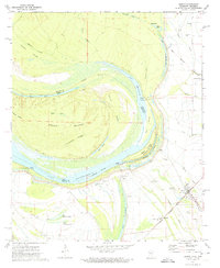
1972 Map of Benoit
USGS Topo · Published 1974About this map
Caulk Island sits at the heart of this oxbow-rich landscape, defined by the winding course of the Mississippi river and its abandoned channels like Whittington Lake. The topography reveals the complex hydrology of the delta, where landforms like Caulk Point and Indian Point are carved by shifting currents. The settlement of Benoit serves as a local hub along the Illinois Central Gulf railroad, surrounded by a network of smaller communities like Hannah and Bolivar. For genealogists and local historians, the map is remarkably dense with landmarks, including numerous rural houses of worship such as Rising Sun Ch and Bold Pilgrim Ch, alongside family-named burial grounds like Burrus Cem and Speckter Cem. The presence of the Old Indian Treaty Boundary cutting across the northeast corner adds a layer of early political history to the mid-20th-century agricultural landscape.
Find a feature on this map
56 named features on this map. Tap any name to fly to it.
Don’t see what you’re looking for? This feature index may not catch every label — zoom into the map to look around manually.
Map Details
Editions of this 1972 Benoit Map
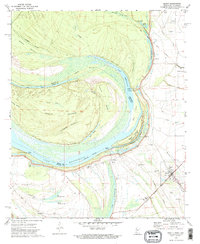
2 editions found
Other maps of this area

1933 · Lamont
USGS Topo · 1:62,500

1939 · Pace
USGS Topo · 1:62,500

1939 · Big Island
USGS Topo · 1:62,500

1939 · Lamont
USGS Topo · 1:62,500

1939 · Choctaw
USGS Topo · 1:62,500

1953 · Greenwood
USGS Topo · 1:250,000

1956 · Greenwood
USGS Topo · 1:250,000

1967 · Stringtown
USGS Topo · 1:24,000

1967 · Lobdell
USGS Topo · 1:24,000
1969 · Choctaw
USGS Topo · 1:62,500