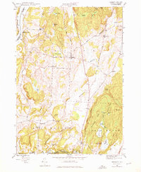
1946 Map of Benson
USGS Topo · Published 1976About this map
The Poultney River and Lake Champlain define the western reaches of this Vermont landscape, where the agricultural community of Benson and the small settlement of West Haven are captured shortly after the war. The topography is dominated by prominent elevations like Shaw Mountain and the steep Great Ledge, which channel the flow of the Hubbardton River toward the south.
Find a feature on this map
66 named features on this map. Tap any name to fly to it.
Don’t see what you’re looking for? This feature index may not catch every label — zoom into the map to look around manually.
Map Details
Editions of this 1946 Benson Map
3 editions found
Other maps of this area

1893 · Whitehall
USGS Topo · 1:62,500

1894 · Ticonderoga
USGS Topo · 1:62,500

1895 · Whitehall
USGS Topo · 1:62,500

1895 · Castleton
USGS Topo · 1:62,500

1896 · Ticonderoga
USGS Topo · 1:62,500

1897 · Castleton
USGS Topo · 1:62,500

1898 · Whitehall
USGS Topo · 1:62,500

1902 · Whitehall
USGS Topo · 1:62,500

1902 · Ticonderoga
USGS Topo · 1:62,500

1902 · Brandon
USGS Topo · 1:62,500