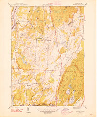
1948 Map of Benson
USGS Topo · Published 1948About this map
Benson and West Haven occupy a landscape defined by the transition from the Champlain shoreline to the interior ridges of Rutland County. In the late 1940s, this area remained largely agrarian, anchored by a dense network of local landmarks including Benson Landing and numerous rural schoolhouses such as Alken Sch and Bump Sch. The Hubbardton River and Poultney River carve through the terrain, supporting local infrastructure like the Carver Falls Dam.
Find a feature on this map
77 named features on this map. Tap any name to fly to it.
Don’t see what you’re looking for? This feature index may not catch every label — zoom into the map to look around manually.
Map Details
Editions of this 1948 Benson Map
2 editions found
Other maps of this area

1893 · Whitehall
USGS Topo · 1:62,500

1894 · Ticonderoga
USGS Topo · 1:62,500

1895 · Whitehall
USGS Topo · 1:62,500

1895 · Castleton
USGS Topo · 1:62,500

1896 · Ticonderoga
USGS Topo · 1:62,500

1897 · Castleton
USGS Topo · 1:62,500

1898 · Whitehall
USGS Topo · 1:62,500

1902 · Whitehall
USGS Topo · 1:62,500

1902 · Ticonderoga
USGS Topo · 1:62,500

1902 · Brandon
USGS Topo · 1:62,500