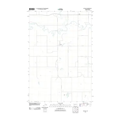
2011 Map of Bentley
USGS Topo · Published 2011About this map
The small settlement of Bentley sits at the heart of this Hettinger County landscape, where the meandering course of the Cannonball River defines the local topography. This 2011 survey illustrates the rural character of the Great Plains, where the grid of sections is etched into the earth by gravel roads and section-line paths like 77th Ave SW and 75th St SW. Genealogy interests are anchored by the Odessa Cemetery in the northern portion of the quadrangle near the crossing of Thirtymile Creek. The map shows a region shaped by agricultural persistence and water management, evidenced by the presence of the Kilzer Dam to the south. Modern infrastructure is represented by the north-south artery of County Hwy 2141, which connects these remote farmsteads and points of interest.
Find a feature on this map
14 named features on this map. Tap any name to fly to it.
Don’t see what you’re looking for? This feature index may not catch every label — zoom into the map to look around manually.
Map Details
Editions of this 2011 Bentley Map
This is the sole edition of this map. No revisions or reprints were ever made.
Other maps of this area

1953 · Dickinson
USGS Topo · 1:250,000

1954 · Bismarck
USGS Topo · 1:250,000

1957 · Dickinson
USGS Topo · 1:250,000

1958 · Bismarck
USGS Topo · 1:250,000

1969 · Burt
USGS Topo · 1:24,000

1969 · North Star Butte
USGS Topo · 1:24,000

1969 · Bentley
USGS Topo · 1:24,000
1969 · Burt NW
USGS Topo · 1:24,000

1972 · Coffin Buttes
USGS Topo · 1:24,000

1972 · New Leipzig South
USGS Topo · 1:24,000