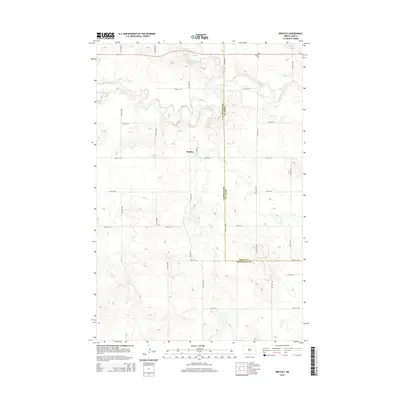
2014 Map of Bentley
USGS Topo · Published 2014About this map
Bentley occupies the heart of this southwestern North Dakota landscape, situated within a grid of section-line roads that define the region's agricultural character. The terrain is bisected by the winding path of the Cannonball River, which meanders through the central and northern sections of the map, joined by the smaller Thirtymile Cr to the north. These watercourses provide a natural counterpoint to the rigid geometric layout of local thoroughfares like 81st Ave SW and 75th St SW. Near the northeastern corner, the Odessa Cem offers a point of genealogical interest, while the political boundary between Grant Co and Hettinger Co runs north to south through the eastern half of the survey, illustrating the administrative divisions of this prairie landscape.
Find a feature on this map
20 named features on this map. Tap any name to fly to it.
Don’t see what you’re looking for? This feature index may not catch every label — zoom into the map to look around manually.
Map Details
Editions of this 2014 Bentley Map
This is the sole edition of this map. No revisions or reprints were ever made.
Other maps of this area

1953 · Dickinson
USGS Topo · 1:250,000

1954 · Bismarck
USGS Topo · 1:250,000

1957 · Dickinson
USGS Topo · 1:250,000

1958 · Bismarck
USGS Topo · 1:250,000

1969 · Burt
USGS Topo · 1:24,000

1969 · North Star Butte
USGS Topo · 1:24,000

1969 · Bentley
USGS Topo · 1:24,000
1969 · Burt NW
USGS Topo · 1:24,000

1972 · Coffin Buttes
USGS Topo · 1:24,000

1972 · New Leipzig South
USGS Topo · 1:24,000