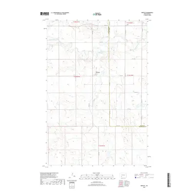
2018 Map of Bentley
USGS Topo · Published 2018About this map
The Bentley settlement serves as the central landmark for this North Dakota prairie landscape, situated near the intersection of Bentley Rd and 75th St SW. The area is characterized by the meandering path of the Cannonball River as it winds through the northern sections, joined by the waters of Thirtymile Cr. This rural expanse sits along the boundary of Hettinger and Grant Counties, where the section lines of the Public Land Survey System dictate a rigid grid of local routes such as 72nd St SW and 76th Ave SW. Genealogists may find particular interest in the Odessa Cem, located in the northeastern corner of the map. The terrain is marked by numerous small wetlands and coulees that feed into the larger river system, reflecting the classic drainage patterns of the northern plains.
Find a feature on this map
21 named features on this map. Tap any name to fly to it.
Don’t see what you’re looking for? This feature index may not catch every label — zoom into the map to look around manually.
Map Details
Editions of this 2018 Bentley Map
This is the sole edition of this map. No revisions or reprints were ever made.
Other maps of this area

1953 · Dickinson
USGS Topo · 1:250,000

1954 · Bismarck
USGS Topo · 1:250,000

1957 · Dickinson
USGS Topo · 1:250,000

1958 · Bismarck
USGS Topo · 1:250,000

1969 · Burt
USGS Topo · 1:24,000

1969 · North Star Butte
USGS Topo · 1:24,000

1969 · Bentley
USGS Topo · 1:24,000
1969 · Burt NW
USGS Topo · 1:24,000

1972 · Coffin Buttes
USGS Topo · 1:24,000

1972 · New Leipzig South
USGS Topo · 1:24,000