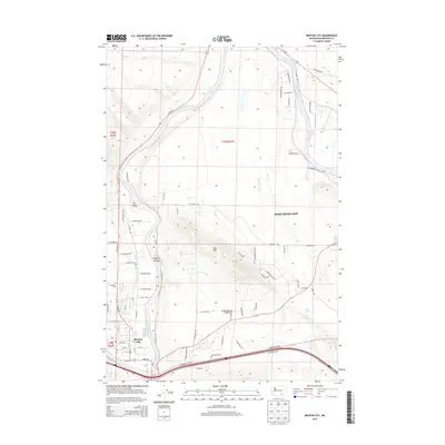
2013 Map of Benton City
USGS Topo · Published 2013About this map
Benton City and West Richland dominate this section of the Yakima River valley, where the landscape transitions from irrigated riverbanks to the steep slopes of Red Mountain. The river creates distinct geographical features such as The Island and Songbird Island, while the McWhorter Canal highlights the region's reliance on water infrastructure for its agricultural development. Local history is anchored by the Evergreen Cemetery and the settlement of Grosscup, located near the southern bend of the river. The map also reveals the complex road network including Wa-240 and Horn Rapids Road, which trace the path of growth in this part of Benton County. Genealogists and researchers can find specific landmarks like Lost Lake and various local thoroughfares such as Harrison Loop and Massinglae Road that define the residential and rural character of the area.
Find a feature on this map
70 named features on this map. Tap any name to fly to it.
Don’t see what you’re looking for? This feature index may not catch every label — zoom into the map to look around manually.
Map Details
Editions of this 2013 Benton City Map
This is the sole edition of this map. No revisions or reprints were ever made.
Other maps of this area

1915 · Prosser
USGS Topo · 1:125,000

1917 · Pasco
USGS Topo · 1:125,000

1917 · Prosser
USGS Topo · 1:125,000

1951 · Richland
USGS Topo · 1:62,500

1951 · Corral Canyon
USGS Topo · 1:62,500

1953 · Walla Walla
USGS Topo · 1:250,000

1958 · Walla Walla
USGS Topo · 1:250,000

1965 · Whitstran
USGS Topo · 1:62,500
1965 · Weber Canyon
USGS Topo · 1:24,000
1965 · Whitstran NE
USGS Topo · 1:24,000