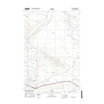
2017 Map of Benton City
USGS Topo · Published 2017About this map
Benton City serves as the focal point for this landscape along the horseshoe bend of the Yakima River, where irrigation infrastructure and topographic elevation define the local economy. The prominent rise of Red Mtn dominates the central terrain, its slopes marked by access roads like S Red Mtn Rd and E Red Mountain Rd, while the McWhorter Canal illustrates the extensive water management systems essential to the region. To the north and west, the river creates distinct landforms such as The Island and Songbird Island, near the turbulent Horn Rapids. Local history and genealogy interests are anchored by the Evergreen Cem and a network of named rural routes, including US Reservation Rd and Jacobs Rd NE, which connect the scattered agricultural tracts and smaller water bodies like Lost Lake.
Find a feature on this map
80 named features on this map. Tap any name to fly to it.
Don’t see what you’re looking for? This feature index may not catch every label — zoom into the map to look around manually.
Map Details
Editions of this 2017 Benton City Map
This is the sole edition of this map. No revisions or reprints were ever made.
Other maps of this area

1915 · Prosser
USGS Topo · 1:125,000

1917 · Pasco
USGS Topo · 1:125,000

1917 · Prosser
USGS Topo · 1:125,000

1951 · Richland
USGS Topo · 1:62,500

1951 · Corral Canyon
USGS Topo · 1:62,500

1953 · Walla Walla
USGS Topo · 1:250,000

1958 · Walla Walla
USGS Topo · 1:250,000

1965 · Whitstran
USGS Topo · 1:62,500
1965 · Weber Canyon
USGS Topo · 1:24,000
1965 · Whitstran NE
USGS Topo · 1:24,000