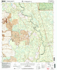
2006 Map of Benton
USGS Topo · Published 2007About this map
The Suwannee River carves a winding path through the borderlands of Hamilton and Columbia Counties, defining a landscape shaped by both conservation and heavy industry. While the eastern reaches are preserved within the Osceola National Forest and the Pinhook Purchase Unit, the western terrain reveals extensive phosphate mining operations. Large-scale Strip Mine excavations and numerous Tailings Pond features dominate the ground west of Sugar Ridge, contrasting sharply with the forested wetlands along Hogans Creek and Hunter Creek. Local heritage is anchored by rural landmarks such as the Benton Lookout Tower and the small settlement of Benton. Traditional community life is evidenced by country houses of worship, including Prospect Ch near the river and Oak Grove Ch to the south, highlighting the area's dual identity as a site of natural resource extraction and quiet woodland habitation.
Find a feature on this map
29 named features on this map. Tap any name to fly to it.
Don’t see what you’re looking for? This feature index may not catch every label — zoom into the map to look around manually.
Map Details
Editions of this 2006 Benton Map
This is the sole edition of this map. No revisions or reprints were ever made.
Other maps of this area

1954 · Valdosta
USGS Topo · 1:250,000

1955 · Council
USGS Topo · 1:24,000

1955 · Cypress Creek
USGS Topo · 1:24,000

1955 · Fargo SW
USGS Topo · 1:24,000

1958 · Valdosta
USGS Topo · 1:250,000

1959 · Valdosta
USGS Topo · 1:250,000

1961 · Deep Creek
USGS Topo · 1:24,000

1961 · White Springs East
USGS Topo · 1:24,000

1961 · White Springs West
USGS Topo · 1:24,000

1962 · Genoa
USGS Topo · 1:24,000