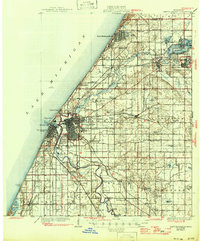
1930 Map of Benton Harbor
USGS Topo · Published 1946About this map
St Joseph and Benton Harbor anchor this Lake Michigan coastal landscape as it appeared in the late 1920s, showing a complex network of lakefront tourism, industrial rail, and agricultural hinterlands. The shoreline is characterized by recreational hubs like Silver Beach and Higman Park, while the inland topography is defined by the winding courses of the Pawpaw River and St Joseph River. A notable cultural landmark is the House of David, located just east of the main city grid. The map records a dense collection of rural educational sites, such as Martindale Sch and Boynton Sch, and specialized facilities including a Fish Hatchery near Milburg. Transportation is a primary theme, with the Pere Marquette and Michigan Central railroads intersecting the region alongside an Electric RR line and the Blue Star Memorial Highway.
Find a feature on this map
86 named features on this map. Tap any name to fly to it.
Don’t see what you’re looking for? This feature index may not catch every label — zoom into the map to look around manually.
Map Details
Editions of this 1930 Benton Harbor Map
4 editions found
Other maps of this area

1927 · Niles
USGS Topo · 1:62,500

1927 · Hartford
USGS Topo · 1:62,500

1927 · Bangor
USGS Topo · 1:62,500

1927 · Benton Harbor
USGS Topo · 1:62,500

1927 · South Haven
USGS Topo · 1:62,500

1930 · Three Oaks
USGS Topo · 1:62,500

1930 · South Haven
USGS Topo · 1:62,500

1930 · Benton Harbor
USGS Topo · 1:62,500

1930 · Niles
USGS Topo · 1:62,500

1931 · Bangor
USGS Topo · 1:62,500