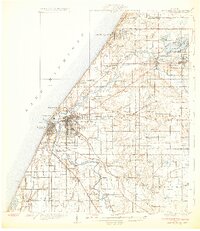
1930 Map of Benton Harbor
USGS Topo · Published 1930About this map
The St Joseph River and Pawpaw River converge at the thriving industrial and resort centers of Benton Harbor and St Joseph during the late 1920s. This survey, compiled in part from early Air Corps aerial photographs, details the unique religious and social landscape of the era, most notably the sprawling House of David colony near the city center. Along the Lake Michigan shoreline, recreational developments like Silver Beach, Edgewater, and Mizpah Park reflect the region's growing identity as a lakeside destination.
Find a feature on this map
93 named features on this map. Tap any name to fly to it.
Don’t see what you’re looking for? This feature index may not catch every label — zoom into the map to look around manually.
Map Details
Editions of this 1930 Benton Harbor Map
4 editions found
Other maps of this area

1927 · Niles
USGS Topo · 1:62,500

1927 · Hartford
USGS Topo · 1:62,500

1927 · Bangor
USGS Topo · 1:62,500

1927 · Benton Harbor
USGS Topo · 1:62,500

1927 · South Haven
USGS Topo · 1:62,500

1930 · Three Oaks
USGS Topo · 1:62,500

1930 · South Haven
USGS Topo · 1:62,500

1930 · Benton Harbor
USGS Topo · 1:62,500

1930 · Niles
USGS Topo · 1:62,500

1931 · Bangor
USGS Topo · 1:62,500