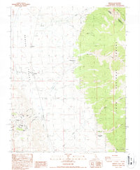
1987 Map of Benton
USGS Topo · Published 1987About this map
Benton Valley serves as the focal point of this 1980s landscape where the high desert meets the steep eastern slopes of the Inyo National Forest. The settlement of Benton is the primary hub, situated near a complex network of canyons and gulches that reveal the area's mining history. The map identifies several historical locations, including Montgomery City (Site) and Queen Dicks (Site), alongside active or former extraction points like the Black Warrior Mine. This transition from the flat valley floor to the prominent heights of Blind Spring Hill and Modoc Peak is marked by the presence of an Inspection Station and various springs. The map also delineates the precise border between California and Nevada, following the historic Von Schmidt Line through the rugged terrain of the White Mountains.
Find a feature on this map
37 named features on this map. Tap any name to fly to it.
Don’t see what you’re looking for? This feature index may not catch every label — zoom into the map to look around manually.
Map Details
Editions of this 1987 Benton Map
This is the sole edition of this map. No revisions or reprints were ever made.
Other maps of this area

1914 · Mt. Morrison
USGS Topo · 1:125,000

1917 · White Mountain
USGS Topo · 1:125,000

1947 · Mariposa
USGS Topo · 1:250,000

1948 · Mariposa
USGS Topo · 1:250,000

1953 · Casa Diablo Mtn
USGS Topo · 1:62,500

1957 · Mariposa
USGS Topo · 1:250,000

1962 · Benton
USGS Topo · 1:62,500

1962 · Glass Mountain
USGS Topo · 1:62,500

1962 · White Mtn. Peak
USGS Topo · 1:62,500

1963 · Mariposa
USGS Topo · 1:250,000