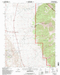
1994 Map of Benton
USGS Topo · Published 1997About this map
The high-desert landscape of Benton Valley is defined by a legacy of mining and the enduring infrastructure of the American West. Centered on the settlement of Benton, the map illustrates a complex network of 4WD trails and an Aqueduct that traverses the arid flats below Blind Spring Hill. The eastern portion is dominated by the steep ascent into the Inyo National Forest and the Boundary Peak Wilderness, where the terrain rises sharply from the valley floor. Historically significant markers like the Von Schmidt Line and the state boundary between California and Nevada highlight the region's geopolitical history. Relics of the silver and gold era are visible at Montgomery City and the Black Warrior Mine, while numerous peaks such as Diana Peak and Modoc Peak provide landmarks for those tracing the mineral-rich geology of the White Mountains range.
Find a feature on this map
41 named features on this map. Tap any name to fly to it.
Don’t see what you’re looking for? This feature index may not catch every label — zoom into the map to look around manually.
Map Details
Editions of this 1994 Benton Map
This is the sole edition of this map. No revisions or reprints were ever made.
Other maps of this area

1914 · Mt. Morrison
USGS Topo · 1:125,000

1917 · White Mountain
USGS Topo · 1:125,000

1947 · Mariposa
USGS Topo · 1:250,000

1948 · Mariposa
USGS Topo · 1:250,000

1953 · Casa Diablo Mtn
USGS Topo · 1:62,500

1957 · Mariposa
USGS Topo · 1:250,000

1962 · Benton
USGS Topo · 1:62,500

1962 · Glass Mountain
USGS Topo · 1:62,500

1962 · White Mtn. Peak
USGS Topo · 1:62,500

1963 · Mariposa
USGS Topo · 1:250,000