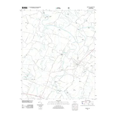
2011 Map of Benton
USGS Topo · Published 2011About this map
The town of Benton serves as a central hub in this Polk County landscape, where the confluence of the Hiwassee River and the Ocoee River shapes the local geography. The river systems are punctuated by numerous named landforms such as Coon Denton Island, Workman Island, and Pinhook Bend, reflecting a long history of water-dependent settlement. Transportation history is evident at Benton Station and historic river crossings like Helderbrand Ford and Reynolds Bridge. For family historians, the sheet is dense with small burial grounds, including the Nancy Ward Cemetery, Chilcutt Cemetery, and Purselley Cemetery. The terrain transitions from the low-lying Boyd Bottoms to prominent heights at Todd Mountain and Sand Mountain, while man-made features like Hoskins Dam and C-C Blankenship Lake indicate modern hydraulic management of the region's abundant creeks.
Find a feature on this map
123 named features on this map. Tap any name to fly to it.
Don’t see what you’re looking for? This feature index may not catch every label — zoom into the map to look around manually.
Map Details
Editions of this 2011 Benton Map
This is the sole edition of this map. No revisions or reprints were ever made.
Other maps of this area

1886 · Cleveland
USGS Topo · 1:125,000

1892 · Cleveland
USGS Topo · 1:125,000

1895 · Cleveland
USGS Topo · 1:125,000

1901 · Cleveland
USGS Topo · 1:125,000

1935 · East Cleveland
USGS Topo · 1:24,000

1935 · Calhoun
USGS Topo · 1:24,000

1935 · Benton
USGS Topo · 1:24,000

1935 · Felker
USGS Topo · 1:24,000

1935 · Charleston
USGS Topo · 1:24,000
1935 · Parksville
USGS Topo · 1:24,000