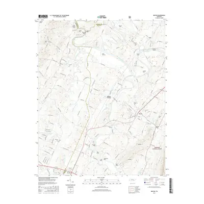
2016 Map of Benton
USGS Topo · Published 2016About this map
The Hiwassee River and Ocoee River define the winding geography of this Polk County landscape, where the valley floor meets the rising timber of the Cherokee National Forest. Local history is anchored by the settlement of Benton and the nearby Benton Station, with the smaller community of Patty situated to the north. The map traces a complex network of river bends and islands, such as Smoky Bend and Guinn Island, which have long influenced the region's agricultural patterns. Genealogical interest is particularly high here, as the sheet marks numerous burial sites including Nancy Ward Cem, Chestuee Cem, and Union Grove Cem. Notable water features like Cassada Pond and McClary Spring appear alongside landmarks such as Reynolds Bridge, illustrating a landscape shaped by both the river economy and the rugged transition into Little Mtn and Sand Mtn.
Find a feature on this map
145 named features on this map. Tap any name to fly to it.
Don’t see what you’re looking for? This feature index may not catch every label — zoom into the map to look around manually.
Map Details
Editions of this 2016 Benton Map
This is the sole edition of this map. No revisions or reprints were ever made.
Other maps of this area

1886 · Cleveland
USGS Topo · 1:125,000

1892 · Cleveland
USGS Topo · 1:125,000

1895 · Cleveland
USGS Topo · 1:125,000

1901 · Cleveland
USGS Topo · 1:125,000

1935 · East Cleveland
USGS Topo · 1:24,000

1935 · Calhoun
USGS Topo · 1:24,000

1935 · Benton
USGS Topo · 1:24,000

1935 · Felker
USGS Topo · 1:24,000

1935 · Charleston
USGS Topo · 1:24,000
1935 · Parksville
USGS Topo · 1:24,000