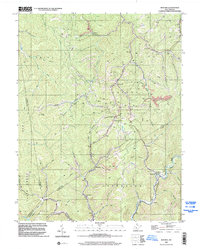
1996 Map of Bentree
USGS Topo · Published 2002About this map
Bentree and its surrounding hollows are defined by the convergence of steep Appalachian ridges and a network of named drainages like Twentymile Creek and Adonijah Fork. The map documents a landscape where community life is anchored by small rural settlements and religious centers such as Lizemores Ch, Indore Chapel, and Ida Ch. The intersection of multiple county lines including Kanawha, Clay, Nicholas, and Fayette counties highlights the region's complex administrative geography. Industrial activity is evident through numerous strip mines and pits located near Ramp Hollow Road, while local education is represented by the Lilly No. 11 School and Brown School. These features, alongside family-named landmarks like Williams Hollow and Bells Fork, provide a detailed record of late-20th-century land use and community structure in this part of West Virginia.
Find a feature on this map
58 named features on this map. Tap any name to fly to it.
Don’t see what you’re looking for? This feature index may not catch every label — zoom into the map to look around manually.
Map Details
Editions of this 1996 Bentree Map
This is the sole edition of this map. No revisions or reprints were ever made.
Other maps of this area

1897 · Kanawha Falls
USGS Topo · 1:125,000

1900 · Kanawha Falls
USGS Topo · 1:125,000

1901 · Kanawha Falls
USGS Topo · 1:125,000

1907 · Clendenin
USGS Topo · 1:62,500

1908 · Clay
USGS Topo · 1:48,000

1908 · Fayetteville
USGS Topo · 1:48,000

1908 · Montgomery
USGS Topo · 1:48,000

1909 · Clendenin
USGS Topo · 1:62,500

1910 · Clay
USGS Topo · 1:62,500

1910 · Fayetteville
USGS Topo · 1:62,500