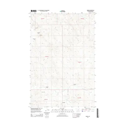
2014 Map of Benzien
USGS Topo · Published 2014About this map
Benzien sits at the intersection of a complex drainage system in this Garfield County landscape, where the Middle Fork Lodgepole Cr and N Fork Lodgepole Cr converge near the Sand Springs Rd. The terrain is defined by a series of significant coulees that carve through the high ground, including the curiously named Seventynine Coulee, Dead Horse Coulee, and Battle Coulee. These deep natural ravines and the prominent Blue Ridge suggest a landscape shaped by intermittent water action and erosion typical of the Montana plains. To the north, the headwaters of Little Nancy Russell Cr and the winding path of Curry Coulee further illustrate the intricate topography of the region as documented in the early 21st century.
Find a feature on this map
18 named features on this map. Tap any name to fly to it.
Don’t see what you’re looking for? This feature index may not catch every label — zoom into the map to look around manually.
Map Details
Editions of this 2014 Benzien Map
This is the sole edition of this map. No revisions or reprints were ever made.
Other maps of this area
1954 · Jordan
USGS Topo · 1:250,000
1956 · Jordan
USGS Topo · 1:250,000
1958 · Jordan
USGS Topo · 1:250,000
1964 · Jordan
USGS Topo · 1:250,000
1965 · Germaine Coulee East
USGS Topo · 1:24,000
1965 · Spring Creek School
USGS Topo · 1:24,000
1965 · Cap Rock Butte
USGS Topo · 1:24,000
1967 · Coffin Butte
USGS Topo · 1:24,000
1967 · Hay Coulee
USGS Topo · 1:24,000
1967 · Searl Coulee
USGS Topo · 1:24,000