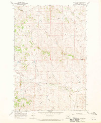
1967 Map of Searl Coulee
USGS Topo · Published 1970About this map
The high, arid plains of Garfield County are defined by a complex network of dry washes and drainage basins in this late 1960s topographical study. The landscape is dominated by the Tindall Divide and the prominent rising form of Battleship Butte, which overlooks a territory carved by numerous named coulees. Water management is central to this environment, evidenced by the presence of the Mashesky Reservoir and Stroud Reservoir, small but vital catchments designed to hold the seasonal flow of the area's many ephemeral forks.
Find a feature on this map
16 named features on this map. Tap any name to fly to it.
Don’t see what you’re looking for? This feature index may not catch every label — zoom into the map to look around manually.
Map Details
Editions of this 1967 Searl Coulee Map
This is the sole edition of this map. No revisions or reprints were ever made.
Other maps of this area

1954 · Jordan
USGS Topo · 1:250,000

1956 · Jordan
USGS Topo · 1:250,000

1958 · Jordan
USGS Topo · 1:250,000

1964 · Jordan
USGS Topo · 1:250,000
1967 · Barney Pinnacle
USGS Topo · 1:24,000
1967 · Froehlich Butte
USGS Topo · 1:24,000
1967 · Cox Butte
USGS Topo · 1:24,000
1967 · Coffin Butte
USGS Topo · 1:24,000
1967 · Hay Coulee
USGS Topo · 1:24,000
1967 · Lelig Coulee
USGS Topo · 1:24,000