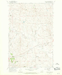
1967 Map of Froehlich Butte
USGS Topo · Published 1970About this map
The high plains of Garfield County are defined by an intricate network of intermittent coulees and distinctive butte formations in this 1967 survey. The landscape is marked by the presence of Calf Creek Sch and the Brown Ranch, anchoring a sparsely populated area where survival depended on the drainage of Calf Creek and its many tributaries. The terrain is dominated by prominent landmarks such as Froehlich Butte and Castle Butte, alongside the curiously named Devils Kitchen. Numerous wells are scattered across the map, highlighting the importance of groundwater in this arid environment. This topographical study captures the ranching character of the region, where family-named features like Buffalo Scott Butte and McTwigan Butte reflect the local history and the enduring presence of early Montana settlers on the open range.
Find a feature on this map
24 named features on this map. Tap any name to fly to it.
Don’t see what you’re looking for? This feature index may not catch every label — zoom into the map to look around manually.
Map Details
Editions of this 1967 Froehlich Butte Map
This is the sole edition of this map. No revisions or reprints were ever made.
Other maps of this area

1954 · Jordan
USGS Topo · 1:250,000

1954 · Forsyth
USGS Topo · 1:250,000

1956 · Jordan
USGS Topo · 1:250,000

1957 · Forsyth
USGS Topo · 1:250,000

1958 · Jordan
USGS Topo · 1:250,000

1958 · Forsyth
USGS Topo · 1:250,000
1963 · Hill Ranch
USGS Topo · 1:24,000
1963 · Mc Williams Springs
USGS Topo · 1:24,000
1963 · Dutton Ranch
USGS Topo · 1:24,000

1964 · Jordan
USGS Topo · 1:250,000