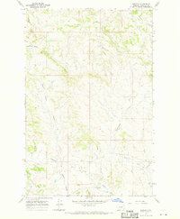
1967 Map of Benzien
USGS Topo · Published 1970About this map
Benzien sits at the base of this Garfield County landscape, positioned near the confluence of several water systems. The terrain is defined by the prominent Blue Ridge, which acts as a topographical spine separating the drainages to the north and south. To the north, Little Squaw Creek and various coulees like Curry Coulee and Seventynine Coulee cut through the high plains, while the southern portion of the map is dominated by the winding path of Lodgepole Creek.
Find a feature on this map
13 named features on this map. Tap any name to fly to it.
Don’t see what you’re looking for? This feature index may not catch every label — zoom into the map to look around manually.
Map Details
Editions of this 1967 Benzien Map
This is the sole edition of this map. No revisions or reprints were ever made.
Other maps of this area

1954 · Jordan
USGS Topo · 1:250,000

1956 · Jordan
USGS Topo · 1:250,000

1958 · Jordan
USGS Topo · 1:250,000

1964 · Jordan
USGS Topo · 1:250,000

1965 · Germaine Coulee East
USGS Topo · 1:24,000

1965 · Spring Creek School
USGS Topo · 1:24,000

1965 · Cap Rock Butte
USGS Topo · 1:24,000
1967 · Coffin Butte
USGS Topo · 1:24,000
1967 · Hay Coulee
USGS Topo · 1:24,000
1967 · Searl Coulee
USGS Topo · 1:24,000