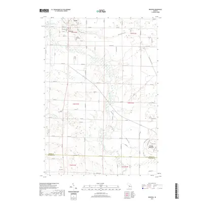
2019 Map of Benzonia
USGS Topo · Published 2019About this map
Benzonia and Beulah serve as the primary hubs in this Benzie County landscape, characterized by the winding course of the Betsie River and its several tributaries including Cold Cr and Dair Cr. The map captures the area's development from the residential streets of the villages to the outlying agricultural and recreational lands. To the southeast, the topography rises toward Buck Hills and the Crystal Mountain resort area, marking a distinct transition from the river valley. Genealogists and local historians can find precise locations for the Benzonia Township Cem near the center of the township and the Joyfield Township Cem further south. The drainage patterns of the N Br Herring Cr and the presence of the Beulah-Benzonia Sewage Disposal Ponds illustrate the modern infrastructure and natural water systems that sustain these communities. A network of rural roads such as Joyfield Rd and Love Rd connect the scattered homesteads across the townships.
Find a feature on this map
81 named features on this map. Tap any name to fly to it.
Don’t see what you’re looking for? This feature index may not catch every label — zoom into the map to look around manually.
Map Details
Editions of this 2019 Benzonia Map
This is the sole edition of this map. No revisions or reprints were ever made.
Other maps of this area

1954 · Traverse City
USGS Topo · 1:250,000

1954 · Manitowoc
USGS Topo · 1:250,000

1956 · Onekama
USGS Topo · 1:62,500

1956 · Thompsonville
USGS Topo · 1:62,500

1956 · Frankfort
USGS Topo · 1:62,500

1957 · Copemish
USGS Topo · 1:62,500

1958 · Traverse City
USGS Topo · 1:250,000

1958 · Manitowoc
USGS Topo · 1:250,000

1976 · Frankfort SE
USGS Topo · 1:24,000

1976 · Frankfort NW
USGS Topo · 1:24,000