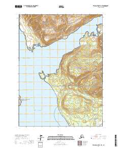
2017 Map of Bering Glacier A-1 SW
USGS Topo · Published 2017About this map
Wrangell-Saint Elias National Park dominates this coastal landscape where massive glacial systems meet the sea. The terrain is defined by dramatic elevation changes as the mountains descend into the Gulf of Alaska, framing the deep inlets of Taan Fiord and Icy Bay. This 2017 survey captures a dynamic shoreline where landforms like Kageet Point and Kichyatt Point break the coastline, marking the boundary between the open ocean and protected waters. Further north, the Alaska Maritime National Wildlife Refuge encompasses coastal islands and sensitive habitats. To the southeast, the Caetani River emerges as a prominent drainage, illustrating the intricate hydrography of this glacial margin. The map serves as a precise record of the topographical features and legal township boundaries, such as t21s r24e, in one of the most wilderness-dense regions of the Yakutat City and Borough.
Find a feature on this map
12 named features on this map. Tap any name to fly to it.
Don’t see what you’re looking for? This feature index may not catch every label — zoom into the map to look around manually.
Map Details
Editions of this 2017 Bering Glacier A-1 SW Map
This is the sole edition of this map. No revisions or reprints were ever made.
Other maps of this area

1948 · Icy Bay D-2 and D-3
USGS Topo · 1:63,360

1950 · Bering Glacier
USGS Topo · 1:250,000

1950 · Icy Bay
USGS Topo · 1:250,000

1951 · Icy Bay D-2 and D-3
USGS Topo · 1:63,360

1951 · Icy Bay
USGS Topo · 1:250,000

1951 · Bering Glacier
USGS Topo · 1:250,000

1951 · Bering Glacier A-2
USGS Topo · 1:63,360
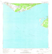
1959 · Icy Bay D-2 and D-3
USGS Topo · 1:63,360

1959 · Bering Glacier
USGS Topo · 1:250,000

1959 · Bering Glacier A-2
USGS Topo · 1:63,360