
1959 Map of Bering Glacier A-2
USGS Topo · Published 1967About this map
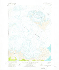
Robinson Mountains dominate this 1959 field survey of the Alaskan coast, where the massive frozen flows of the Yahtse Glacier and Guyot Glacier converge toward the sea. The map documents a landscape defined by glacial movement and drainage, with the Guyot Hills rising as a prominent topographic divide between these ice fields. Along the southeastern edge, the waters of Icy Bay reach the shore, fed by the runoff from Independence Creek.
Find a feature on this map
10 named features on this map. Tap any name to fly to it.
Don’t see what you’re looking for? This feature index may not catch every label — zoom into the map to look around manually.
Map Details
Editions of this 1959 Bering Glacier A-2 Map
2 editions found
Other maps of this area

1948 · Icy Bay D-2 and D-3
USGS Topo · 1:63,360

1950 · Bering Glacier A-3
USGS Topo · 1:63,360

1950 · Bering Glacier
USGS Topo · 1:250,000

1950 · Icy Bay
USGS Topo · 1:250,000

1951 · Icy Bay D-2 and D-3
USGS Topo · 1:63,360

1951 · Icy Bay
USGS Topo · 1:250,000

1951 · Bering Glacier
USGS Topo · 1:250,000

1951 · Bering Glacier A-2
USGS Topo · 1:63,360
1959 · Icy Bay D-2 and D-3
USGS Topo · 1:63,360

1959 · Bering Glacier
USGS Topo · 1:250,000