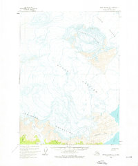
1959 Map of Bering Glacier A-2
USGS Topo · Published 1976About this map
Guyot Glacier and the Yahtse Glacier dominate this mid-century topographical survey of the Alaskan coast. The map provides a critical look at glacial recession, with specific blue-ticked lines indicating the shifting limits of the ice through the late 1950s as it retreated from the shores of Icy Bay. To the south, the Robinson Mountains rise sharply from the coastline, dissected by several coastal drainage systems including Independence Creek and Sandy Creek.
Find a feature on this map
15 named features on this map. Tap any name to fly to it.
Don’t see what you’re looking for? This feature index may not catch every label — zoom into the map to look around manually.
Map Details
Editions of this 1959 Bering Glacier A-2 Map
2 editions found

Other maps of this area

1948 · Icy Bay D-2 and D-3
USGS Topo · 1:63,360

1950 · Bering Glacier A-3
USGS Topo · 1:63,360

1950 · Bering Glacier
USGS Topo · 1:250,000

1950 · Icy Bay
USGS Topo · 1:250,000

1951 · Icy Bay D-2 and D-3
USGS Topo · 1:63,360

1951 · Icy Bay
USGS Topo · 1:250,000

1951 · Bering Glacier
USGS Topo · 1:250,000

1951 · Bering Glacier A-2
USGS Topo · 1:63,360
1959 · Icy Bay D-2 and D-3
USGS Topo · 1:63,360

1959 · Bering Glacier
USGS Topo · 1:250,000