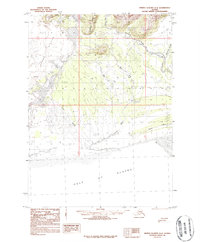
1984 Map of Bering Glacier A-4
USGS Topo · Published 1987About this map
The Bering Glacier dominates the western portion of this coastal landscape, where the glacial ice gives way to a complex network of glacial outwash and braided river systems. Flowing toward the Gulf of Alaska, the Kaliakh River and the Tsiu River carve through vast sandy flats and silt deposits. This 1984 provisional study reveals the dynamic nature of the shoreline, marked by shifting river mouths and the Moraine on Glacier that speaks to the massive scale of the retreating ice. Higher elevations are defined by the Grindall Hills and Donald Ridge, which flank the Koseakus River valley. A solitary Drill Hole near the West Fork provides a rare indication of human exploration or resource surveying in this remote stretch of the Alaskan coast during the early 1980s.
Find a feature on this map
19 named features on this map. Tap any name to fly to it.
Don’t see what you’re looking for? This feature index may not catch every label — zoom into the map to look around manually.
Map Details
Editions of this 1984 Bering Glacier A-4 Map
This is the sole edition of this map. No revisions or reprints were ever made.
Other maps of this area

1948 · Bering Glacier A-4
USGS Topo · 1:63,360

1950 · Bering Glacier A-3
USGS Topo · 1:63,360

1950 · Bering Glacier
USGS Topo · 1:250,000

1950 · Icy Bay
USGS Topo · 1:250,000

1951 · Icy Bay
USGS Topo · 1:250,000

1951 · Bering Glacier
USGS Topo · 1:250,000
1951 · Bering Glacier A-4
USGS Topo · 1:63,360

1959 · Bering Glacier
USGS Topo · 1:250,000
1959 · Bering Glacier A-3
USGS Topo · 1:63,360
1959 · Bering Glacier A-4
USGS Topo · 1:63,360