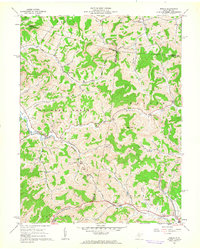
1961 Map of Berlin
USGS Topo · Published 1962About this map
The hill country of Lewis and Upshur counties is defined here by an intricate network of narrow valleys and winding creeks, where small settlements like Berlin and Lorentz took root along the waterways. The landscape in the early 1960s was dominated by a mix of traditional agriculture and a burgeoning extraction economy, evidenced by numerous Strip Mines and scattered oil wells throughout the hills. Religious and educational life centered on locations such as the Buckhannon Run Ch, Jesse Run Ch, and the White Oak Grove Sch.
Find a feature on this map
47 named features on this map. Tap any name to fly to it.
Don’t see what you’re looking for? This feature index may not catch every label — zoom into the map to look around manually.
Map Details
Editions of this 1961 Berlin Map
2 editions found
Other maps of this area

1893 · Buckhannon
USGS Topo · 1:125,000

1896 · Buckhannon
USGS Topo · 1:125,000

1897 · Buckhannon
USGS Topo · 1:125,000

1904 · Philippi
USGS Topo · 1:62,500

1904 · Weston
USGS Topo · 1:62,500

1912 · Sago
USGS Topo · 1:48,000

1912 · Crawford
USGS Topo · 1:48,000

1914 · Sago
USGS Topo · 1:62,500

1914 · Crawford
USGS Topo · 1:62,500

1925 · Philippi
USGS Topo · 1:62,500