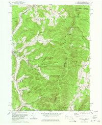
1973 Map of Berlin
USGS Topo · Published 1975About this map
The Hoosic River and its tributary, the Little Hoosic River, carve a deep valley through the northern Taconic Range in this mid-1970s survey. Settlements like Petersburg and Berlin anchor the narrow corridor of flatland, while the steep eastern slopes define the tri-state border of New York, Massachusetts, and Vermont. This landscape is a patchwork of conservation and early recreation, featuring the State Reforestation Area and the Taconic Trail State Park. Of particular interest to winter sports historians are the Taconic Trails Ski Area and Williams College Ski Area, both established on these slopes. The map also reveals the rural fabric of the era through sites like the Carmelite Novitiate and the Cherryplain Sch. Extensive hollows named for local families, including Satterlee Hollow, Cowdry Hollow, and Mattison Hollow, extend from the valley floor into the heights of Berlin Mtn and Miser Mountain.
Find a feature on this map
62 named features on this map. Tap any name to fly to it.
Don’t see what you’re looking for? This feature index may not catch every label — zoom into the map to look around manually.
Map Details
Editions of this 1973 Berlin Map
4 editions found
Other maps of this area

1886 · Greylock
USGS Topo · 1:62,500

1888 · Berlin
USGS Topo · 1:62,500

1890 · Berlin
USGS Topo · 1:62,500

1891 · Greylock
USGS Topo · 1:62,500

1893 · Greylock
USGS Topo · 1:62,500

1894 · Berlin
USGS Topo · 1:62,500

1897 · Hoosick
USGS Topo · 1:62,500

1898 · Berlin
USGS Topo · 1:62,500

1898 · Bennington
USGS Topo · 1:62,500

1898 · Greylock
USGS Topo · 1:62,500