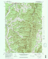
1973 Map of Berlin
USGS Topo · Published 1978About this map
The valley of the Little Hoosic River serves as the primary corridor for settlement and transit in this portion of the Rensselaer County highlands during the early 1970s. Linear communities such as Petersburg, Berlin, Center Berlin, and Cherryplain follow the river and the Boston and Maine Railroad north-south, while the surrounding terrain is dominated by steep ridges. To the east, the state lines of Vermont and Massachusetts intersect atop the Taconic Range, where the Taconic Crest Trail traverses peaks like Berlin Mtn and Misery Mountain. The landscape reveals a mix of recreational and academic influences, featuring the Williams College Ski Area and the Carmelite Novitiate. Numerous "hollows" such as Mattison Hollow and Greene Hollow cut into the mountains, documenting the local family names tied to these drainage basins and narrow valley roads.
Find a feature on this map
68 named features on this map. Tap any name to fly to it.
Don’t see what you’re looking for? This feature index may not catch every label — zoom into the map to look around manually.
Map Details
Editions of this 1973 Berlin Map
4 editions found
Other maps of this area

1886 · Greylock
USGS Topo · 1:62,500

1888 · Berlin
USGS Topo · 1:62,500

1890 · Berlin
USGS Topo · 1:62,500

1891 · Greylock
USGS Topo · 1:62,500

1893 · Greylock
USGS Topo · 1:62,500

1894 · Berlin
USGS Topo · 1:62,500

1897 · Hoosick
USGS Topo · 1:62,500

1898 · Berlin
USGS Topo · 1:62,500

1898 · Bennington
USGS Topo · 1:62,500

1898 · Greylock
USGS Topo · 1:62,500