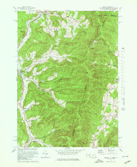
1973 Map of Berlin
USGS Topo · Published 1978About this map
The Hoosic River valley and the high ridgelines of the Taconic Range define this 1970s landscape along the borders of New York, Massachusetts, and Vermont. Small settlements like Petersburg, Berlin, and Center Berlin follow the north-south corridor of the Little Hoosic River, mirroring the path of the Rutland Railroad. The map captures a moment of active recreational land use, featuring the Petersburg Pass Ski Area and the Williams College Ski Area, while preserving geological curiosities such as The Snow Hole near Smith Hill. Extensive public lands including the State Reforestation Area and Taconic Trail State Park dominate the eastern uplands. Numerous family-named hollows, such as Greene Hollow and Mattison Hollow, cut into the mountainsides, illustrating the long-standing agricultural and timber legacy of Rensselaer County.
Find a feature on this map
51 named features on this map. Tap any name to fly to it.
Don’t see what you’re looking for? This feature index may not catch every label — zoom into the map to look around manually.
Map Details
Editions of this 1973 Berlin Map
4 editions found
Other maps of this area

1886 · Greylock
USGS Topo · 1:62,500

1888 · Berlin
USGS Topo · 1:62,500

1890 · Berlin
USGS Topo · 1:62,500

1891 · Greylock
USGS Topo · 1:62,500

1893 · Greylock
USGS Topo · 1:62,500

1894 · Berlin
USGS Topo · 1:62,500

1897 · Hoosick
USGS Topo · 1:62,500

1898 · Berlin
USGS Topo · 1:62,500

1898 · Bennington
USGS Topo · 1:62,500

1898 · Greylock
USGS Topo · 1:62,500