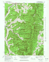
1973 Map of Berlin
USGS Topo · Published 1978About this map
Petersburg and Berlin anchor a landscape defined by the steep ridges of the Taconic Mountain range during the early 1970s. The geography is characterized by numerous deep hollows, such as Jones Hollow, East Hollow, and Southeast Hollow, which channeled early settlement and agricultural patterns along the Hoosic River and Little Hoosic River. This era shows a transition toward recreational land use, evidenced by the Taconic Trail Ski Area and Williams College Ski Area carved into the hillsides.
Find a feature on this map
55 named features on this map. Tap any name to fly to it.
Don’t see what you’re looking for? This feature index may not catch every label — zoom into the map to look around manually.
Map Details
Editions of this 1973 Berlin Map
4 editions found
Other maps of this area

1886 · Greylock
USGS Topo · 1:62,500

1888 · Berlin
USGS Topo · 1:62,500

1890 · Berlin
USGS Topo · 1:62,500

1891 · Greylock
USGS Topo · 1:62,500

1893 · Greylock
USGS Topo · 1:62,500

1894 · Berlin
USGS Topo · 1:62,500

1897 · Hoosick
USGS Topo · 1:62,500

1898 · Berlin
USGS Topo · 1:62,500

1898 · Bennington
USGS Topo · 1:62,500

1898 · Greylock
USGS Topo · 1:62,500